Satellite and mapping technologies like Google maps have proven to be powerful tools for independent researchers and explorers around the world. While some sensitive places – like military installations and private residences – still remain out of view, most parts of the planet are now free to explore by anyone with a computer and a few hours to kill.
Surprisingly, that has only raised more questions than answers, as we can now see everything we don’t know about Earth from a bird’s eye perspective, and in full HD. Thanks to the rise of easily-accessible services like Google Maps and Google Earth, we now know of far more mysterious and unexplained places around the world than we did before.
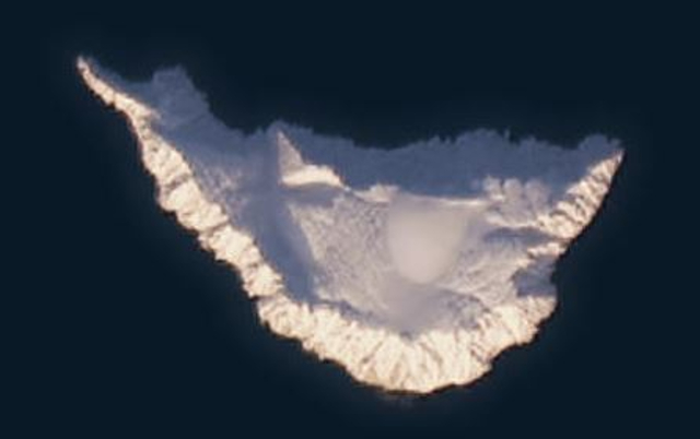
10. Surtsey Island
Surtsey is a volcanic island located off the southern coast of Iceland. It was formed by a volcanic eruption in 1963, making it one of the youngest islands in the world. The eruption continued for about three and a half years, and by the time it was finished, the island had grown to an area of around 2.7 square kilometers, or 1.04 square miles.
Because of its age and isolation, Surtsey provides scientists with a rare opportunity to study the formation of a whole new ecosystem in real time. Access to the island is therefore strictly controlled, and it’s currently only open for exploration by scientists.
For now, there are still many things we don’t know about Surtsey Island’s topography and ecology. It might even be one of the last unexplored places on Earth, as it’s believed that many of the species found here are unique to the island.
9. The Kazakh Geoglyphs

In 2007, researchers using Google Earth stumbled upon a bunch of massive symbols somewhere in the steppes of northern Kazakhstan. These enormous designs, which can only be spotted and appreciated from high up in the air, include images of animals, geometric shapes, and other mysterious symbols we’ve never been able to decipher.
Mostly made of earthen mounds, the exact purpose and meaning of these glyphs is still a mystery. Some believe they might have been used for religious or ceremonial purposes, while others think that they’re some sort of navigational markers. Their age is also uncertain, with estimates ranging from a few hundred years to over 8,000 years old. We don’t know whether they were built by a lost civilization or just a very dedicated group of hunter-gatherers, either, challenging our whole notion of what people that long ago were capable of doing.
8. Azraq Oasis
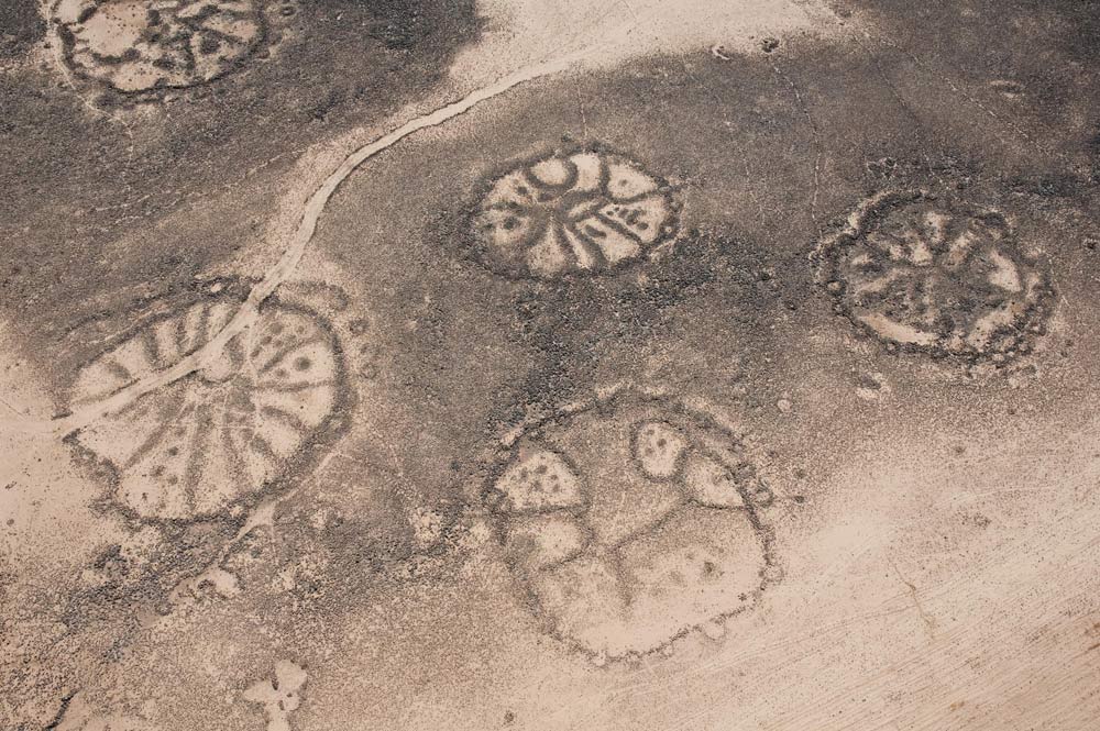
First described by a British RAF Flight Lieutenant, Percy Maitland, in 1927, the wheel-like series of stone structures in Azraq Oasis, Jordan, remain a mystery to this day. While we don’t know about all of them, two of the patterns have since been found to be at least 8,500 years old. The nomadic Bedouin tribes in the region call them “Works of Old Men”, which includes other similar works scattered across Syria, Jordan, Saudi Arabia, and Yemen.
So far, we don’t know much about these structures, except for the fact that the stone material used to build them was brought in from many miles away, which requires some sort of a coordinated effort on a large scale. One study suggests that they were used in astronomy, as the spokes of some of the wheels are aligned in a southeast – northwest direction. That’s still only a guess, however, as the alignment is not common to all the wheels in the set.
7. The Navy Base Shaped Like The Swastika
Some time in 2007, Internet users messing around with Google Earth noticed something rather interesting about the Coronado Navy base in southern California. While it seems like a normal building with multiple L-shaped sections from the ground, the building was clearly shaped like the Nazi swastika from the air.
While the military agreed that it looked bad and promised to fix it, no reports suggest that it was fixed. As you’d expect, the discovery sparked a slew of conspiracy theories online, like the one about German POWs from WW2 secretly building it as a tribute to Adolf Hitler. Another theory says that the base resembles a set of Calvary crosses and points to Jerusalem.
While it’s unlikely that any of these outlandish theories are actually true, some records do suggest that the Navy knew about the swastika before the building was completed. In reality, the whole thing might have just been an oversight by individual building planners, instead of any grand Nazi conspiracy within the United States.
6. The Phantom Island

On September 15, 1774, British navigator Captain James Cook and his crew spotted an island off the coast of Australia, which they promptly named Sandy Island and added to their maps. From then on, the island was included on all other maps for centuries, marked as a small landmass located between Australia and New Caledonia.
In November 2012, however, a team of Australian scientists on a research expedition tried to visit it, only to realize that the landmass doesn’t exist. It was even marked on Google maps until this point, though they removed it later that year. Now, one can see a visible rise in the sea bed where the island should be, sparking all kinds of controversies surrounding it. While it’s possible that the island doesn’t exist and there really is nothing at that location, Sandy Island has been a center of conspiracies and other alternative theories ever since the story first came to light.
5. Mount Lico
Mount Lico is a remote, isolated mountain in northern Mozambique. While it has always been known to the locals, it wasn’t until 2012 that it gained international recognition, when a scientist – Dr. Julian Bayliss – discovered a whole rainforest on top of it via Google Earth. He gathered a 28-person team of engineers, biologists, rock climbers, and other experts in their fields, and decided to go check for himself.
What Bayliss found is now recognized as one of the last truly unexplored places on Earth. The top of Mount Lico is home to a whole new tropical jungle that has never been disturbed by outside interference. They found a new butterfly species, a bunch of small mammals and reptiles, and an unknown species of amphibians they had never seen before, and they’ve only just started exploring the place. Mysteriously, the team also found some upturned pots near a stream, which might mean some sort of a human presence in the area before the team’s first expedition.
4. Jeannette Island
Some time in 2018, Internet users discovered that Jeannette Island – a remote Russian island in the East Siberian Sea – had turned into a black blob on Google Maps. It was named after the USS Jeannette – an American ship that got stuck there in 1881. The crew was trying to find the fabled polar route to the open waters of the Arctic, though ultimately to little success. They claimed the territory in the name of the American government, and proceeded to get out of there as soon as they could because it was still a remote icy island in the middle of nowhere.
Since then, it’s unclear whether the island belongs to the USA or Russia, as both the countries claim it over the other. While that might be the reason for its disappearance on Google Maps, the Internet – as usual – has all kinds of alternative theories about it, including ones involving aliens and secret military bases.
3. Mururoa Island
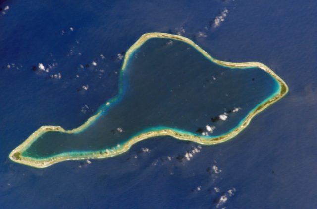
Mururoa is a small French Polynesian island located in the South Pacific Ocean. Between 1966 and 1996, it was extensively used as a nuclear testing site by France, with over 193 tests conducted throughout this period. These tests and the subsequent contamination of the local environment on the island have since been a matter of controversy, and we still don’t have a clear idea about the extent of the damage.
The nuclear program was halted in 1996 due to international and local pressure, and Mururoa Island has since remained largely uninhabited and off-limits to the public. As of now, part of it is completely blurred out on Google Maps, likely to keep its bombed-out topography and other details about the tests out of public view. It’s also protected by the French military for some reason, which only adds to the overall mystery.
2. Random Shapes In The Gobi Desert
The story of the mysterious megastructures in China’s Gobi desert was first broken by Gizmodo in 2011. Since then, readers and other Internet users have discovered even more of these mystery structures, often shaped in neat geometric shapes like squares and circles. Apart from the fact that they’re located in the middle of nowhere, they seem to serve no apparent purpose at all, even if someone clearly spent a lot of time building them.
Some people have suggested that they’re ancient ruins once used for navigation of some kind, possibly dating back to the Silk Road era. Others say that they’re parts of a secret Chinese military facility, or even a secret base for classified research. According to one theory, they’re merely airstrips or roads built for industrial purposes in the remote desert, even if one of the structures is bright blue in color for no apparent reason.
1. Nazca Lines
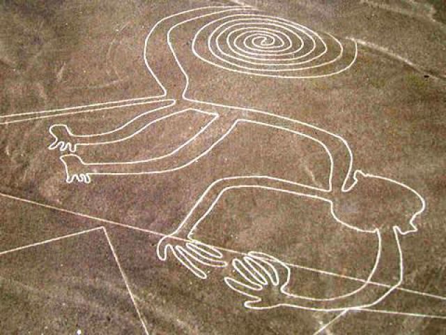
The Nazca lines are a series of ancient geoglyphs located in the Nazca desert of southern Peru. They were discovered in the 1920s, when commercial airlines began flying over the region and pilots reported seeing strange markings on the ground for the first time. The lines, which include images of animals, humans, and various geometric shapes, are so large that they can only be fully appreciated from the air.
As you can tell from the overall theme of this list, we still don’t know who made them and why. Theories say that they were used for astronomical observations, religious rituals, or some kind of ancient communication, though no evidence exists to prove or disprove either of them. The lines remain one of the most mysterious ancient structures we’ve ever discovered, comprising over 800 straight lines, 300 distinct geometric figures, and 70 animal and plant motifs, which includes 168 geoglyphs that were only discovered in December 2022.