The popular depiction of archaeologists covered in dust, carrying an assortment of small shovels, brushes, and various other analogue tools is basically a thing of the past. If Indiana Jones were to be re-envisioned today, he might look a lot more like a character out of a science fiction film, carrying scanning devices that can directly analyze the chemical composition of soil, probes that can map out a general area of an archaeological site, and even utilizing UAV drones to explore dangerous areas (thereby avoiding those pesky snake and boulder traps).
Indeed, the technology that is now aiding archaeologists has helped to revolutionize and greatly expand our knowledge of prehistoric and ancient societies, and it helps make the field look pretty darned cool too.
Here are 10 incredible ways modern technology has aided archaeology.
10. Google Earth

Google Earth is the descendant of a CIA-funded satellite imaging project. Since its launch in 2005, its functionality has been greatly expanded to include GPS, map direction capabilities, presentations for the real estate industry, flight simulators, and other games, and it’s also become a hugely popular tool for both amateur and a small number of professional archaeologists.
Archaeologists used aerial photography for decades, long before the first satellite was launched into orbit. But Google Earth and open-access satellite imaging programs like it are basically utilized in the same way, the difference is that both the resolution and scope of the images taken by those satellites are far more clear and much larger.
Amateurs and pros alike will identify potential sites by analyzing markings in the land, or by searching for signs of ancient structures. In one example, an amateur archaeologist identified a strange shape in the hedge line of a man’s farm. That shape turned out to be the burial site of a huge trove of Saxon coins, valued at $1.5 million.
However, while some archaeologists will admit that Google Earth has some utility, they are also horrified that basically anyone can access this information and track down important archaeological sites before they can be officially cataloged and preserved.
9. Soil Geochemistry
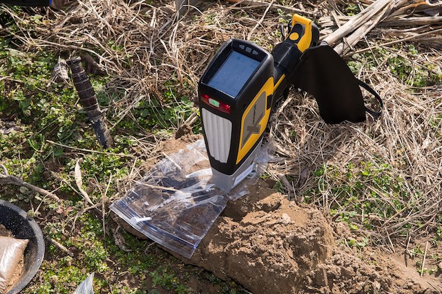
Sometimes an archaeological site may be so degraded due to erosion and decomposition of artifacts that little to no visible evidence is left behind for archaeologists to find. But humans always leave behind a footprint and developing technologies have allowed for the analysis of soil geochemistry, giving archaeologists more tools for uncovering humanity’s past.
When humans occupy land, they change the soil chemistry in ways that can be detected using sophisticated analysis techniques and handheld machines that can scan soil samples on the field. The Z300 handheld is one such device, capable of scanning soil samples with its built-in camera and delivering data in mere moments.
With devices like the Z300, archaeologists are able to detect any element on the periodic table. These devices allow archaeologists to obtain additional context as to how humans lived in these areas, as the elements detected in the soil they used directly inform on what sort of technology and lifestyles they led.
8. Drone Technology
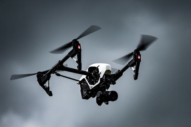
On average, at least three people die every year while exploring caves. Unmanned drones have the benefit of not being, you know, sentient, and therefore not fleshy and easily squished. Some archaeological sites are located in dangerous places that can put human archaeologists at risk. Using UAVs and other types of drones, archaeologists are able to map cave systems, allowing for 3D maps with proper lighting that can then be explored by the archaeologist without the need of risking their lives.
This greatly speeds up the rate at which archaeologists are able to execute an archaeological operation.
Before drone technology, archaeologists would comb fields on foot, taking hours to search a potential site for pottery shards and other artifacts. With the aid of drones in conjunction with good old fashioned foot surveys, they’re able to create a complete map of the site and cut the time it takes to conduct a survey down by a significant margin.
7. Ground Penetrating Radar
Geophysical surveying methods are invaluable tools that allow archaeologists to determine where they should focus their excavation efforts, and ground-penetrating radar may just be the best tool for the job, as it’s one of the only technologies that gives them important information about a given location but also informs them of what lies beneath the surface of a site without ever having to pick up a shovel.
Ground-penetrating radar is also non-invasive, meaning that important archaeological artifacts won’t be damaged during an excavation. It works by using electromagnetic radiation in the microwave band to image the earth beneath our feet.
This has resulted in some seriously stunning discoveries, like the Viking burial ship that was found beneath the surface of Norway in 2019. Ground Penetrating Radar allowed for extremely precise measurements of the ship and the discovery of a religious site, feasting hall, and a farmhouse.
6. CT Scanners and 3D Modeling Software

Delicate artifacts can easily be damaged when handled by scholars and students, potentially destroying priceless information in the process. But thanks to CT scanners and 3D modeling software, those artifacts can be accurately recreated and reassembled without the risk of damaging the original artifact.
High-resolution tomographic imaging utilizes x-rays that are then taken and processed into 2D and 3D dimensional images, and with the advances that have been made in the realm of microCT technology, artifacts can be imaged at the molecular level.
But 3D surface scanning with the aid of lasers has become even more widely used than CT scanning technology in archaeology. This technology creates high-resolution 3D models of artifacts at a fraction of the cost of expensive CT scanners.
While these scanners don’t utilize x-rays, and can’t image an object at the molecular level, they’re often portable enough to be used with a laptop.
5. Shallow Geophysics

While shallow geophysics can be a time-consuming operation, the probes used in this method offer great insight to archaeologists who wish to study sites where nearby populations are beginning to expand.
As explained earlier, human occupation has the potential to chemically change the soil of archaeological sites and that also goes for sites near large population centers. These places can cause serious damage to historical sites that should be protected. But shallow geophysics offers a way to produce an image and reconstruct what sites were originally like in their prime by using Earth’s magnetic field and even gravity.
This technology is essentially a form of remote sensing that focuses on a depth of about 1.5 meters (rather than ground-penetrating radar, which has a much greater depth of penetration).
Magnetometery basically measures the strength of the magnetic field, using it to map the reflected pattern of objects buried in the soil. These techniques used in conjunction with GPS technology have proved quite useful in surveying sites like Stonehenge.
4. Portable X-Ray Fluorescence Spectroscopy
Handheld XRF devices are typically used by scientists, scholars, and students in universities as well as in the field. These devices utilize x-rays to analyze artifacts and samples, providing archaeologists with incredible information about soil composition and invisible pigmentation that have faded on ceramics, and the devices are particularly ideal for analyzing obsidian artifacts.
Portable x-ray fluorescence is also a bit more cost-effective than some techniques like CT scanners.
XRF techniques have also aided museums and universities greatly in discovering which potential artifacts are fakes. This is accomplished by comparing information on the different paints and chemicals used to color an artifact with our knowledge of what ancient peoples had access to and actively used. If modern chemicals are discovered in a piece, then it’s more than likely that the artifact in question is a forgery.
3. Radiometric Dating
Relative dating is when objects closer to the surface are thought to be younger than objects that are present in deeper layers of soil or strata. There are obvious problems with this approach because rodents and natural disasters can cause artifacts to be displaced and therefore changing the “context” in which archaeologists discover them.
Absolute dating is far more accurate and effective at establishing the true age of an artifact. There are a variety of types of radiometric dating, each with varying levels of accuracy. Radiocarbon dating, for example, measures the decay of Carbon14 isotopes in artifacts with organic materials and is accurate for items that are less than 50,000 years old, up to a younger limit of 400 years.
But archaeologists can also use other elements, such as potassium-argon dating, which yields accurate results of up to 4.3 billion years to about 100,000 years if the proper methods are used.
Uranium-lead dating is extremely accurate, measuring the age of objects up to 250,000 years old in some circumstances.
2. Forensic Technology
Today archaeologists are able to use a variety of tools to reconstruct historical events that are typically only thought of as tools used by police. Forensic techniques and technology can be hugely beneficial to scholars. From analyzing the bone structures of a specimen, they can effectively reconstruct how that historical person died.
DNA in mummies and other fossilized bodies (like those Neolithic corpses discovered in thawing tundra) can help establish the sex of ancient people, as well as that person’s ancestral heritage.
In 2012, a human male skeleton was discovered by an archaeological team beneath a car park in Leicester, England. Thanks to DNA analysis it was discovered that the skeleton belonged to none other than Richard III, who died in the Battle of Bosworth in 1485.
1. LiDAR
It’s definitely no exaggeration to say that LiDAR technology has changed the face of archaeology, with some saying that the tech has effectively ignited a revolution within the field.
LiDAR works by shooting out hundreds of thousands of pulses of light toward the ground, usually from a height of about 606 meters. As those pulses of light bounce back to the aircraft, they’re measured, and each point’s GPS location is logged to create a 3D map of the area.
This technology is especially accurate at ground level, showing the tiniest details of archaeological structures, even revealing burial mounds and sunken cities.
In the early 2010s, archaeologists were shocked when LiDAR technology stumbled upon a lost Mayan city. In another case, it revealed tens of thousands of archaeologically significant structures in an area of Mexico that had previously been thought to be insignificant.
It might surprise you to find out that a large portion of New England in the US is of particular interest to archaeologists because during the 1700s these forested areas were occupied by roads and settlements. These settlements largely disappeared during the 1950s and nature reclaimed the space. Because of the heavy tree cover in these areas, it’s difficult for archaeologists to get a fix on these sites, but LiDAR is helping to unlock the secrets of these abandoned settlements.