Maps have been around for almost as long as civilization and the concept of getting lost and refusing to ask for directions. They’ve ranged from the whimsical to the bizarre, and they’ve changed the world and how we look at it. These 10 were especially important.
10. Turin Papyrus Map (1150 B.C.E.)
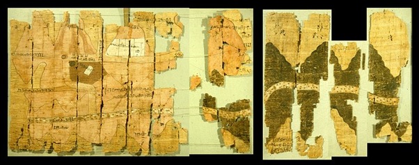
The Turin Papyrus Map is the oldest topographical map to have survived into modern times. It was created for the use of Ramses IV, who was busy attempting to outdo some of the greatest engineering projects in history, such as the Pyramids. To do this, he needed a Metric Seth-ton of rock dug out of the desert and hauled to building sites.
This map was created explicitly to provide him with the stones he needed for his monuments. It depicts the entirety of Egypt’s Wadi Hammamat region with a degree of precision that rivals modern day geological mapping projects. The map also shows where the local gold mines, towns and sandstone quarries are to be found. This combination of geographic and geologic structures into a single, precise map for industrial use is often considered to be the world’s first Geographic Information System projection.
9. Eratosthenes’ Map of the Known World (194 B.C.E.)
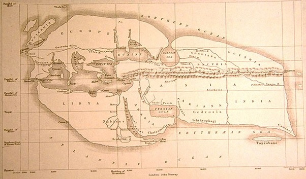
The most famous library in history was the Library of Alexandria. While its fame is largely due to being one of the first and largest libraries in existence, it should also be famous for some of the people who hung out there. Its head librarian in the 2nd century B.C.E. was Eratosthenes, who in addition to shelving books and shushing patrons was a scientist and philosopher.
Eratosthenes’ intellect left other Greek scientists and philosophers in awe. Using the resources available from the Library, he calculated the tilt of the Earth on its axis, the length of a solar year (and thus the need for a leap year) and the distance to the sun. He then took these calculations and used them to accurately figure out the positions of objects on a north-south and east-west grid, a system that would become known as latitude and longitude.
8. Ning-hai County, China (1200s)
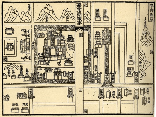
The Chinese invented bureaucracy long before it was the twinkle of any politician’s eye in the West. Their ancient and complex system of civil service exams and complicated governmental structures required entire industries to function, and even required bureaucrats to manage bureaucrats, producing a model for government contractors to follow to this day.
One of the things that made this work well was the Chinese system of maps. Every significant government appointee would start out their assignment with a packet that included a map of their jurisdiction. This map included census data, trade and tax data, and local social behavior. An army of cartographers were employed to constantly update these maps, a practice that is today fulfilled by organizations such as the United States Geological Survey and the Ordnance Survey.
7. Henricus Martellus’ World Map (1490)
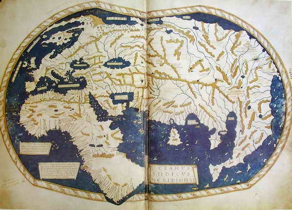
Henricus Maretellus’ map wasn’t the most accurate of its day. The further East you went, the less likely you were to actually get where you were going. To be blunt, it was a terrible map if you needed to get anywhere at all. It did, however, have a couple of very important things that it got right.
First, it was the first time someone attempted to depict the world as being round. There’s a popular theory that this very map was the one Christopher Columbus used to convince the Spanish he could get to India by sailing West. Also take note of the depiction of a water route around the bottom of Africa. This convinced the Dutch they could get to India by sailing South. The direct result of these two facts would lead to European colonization and domination of the Americas and Asia for the next 500 years.
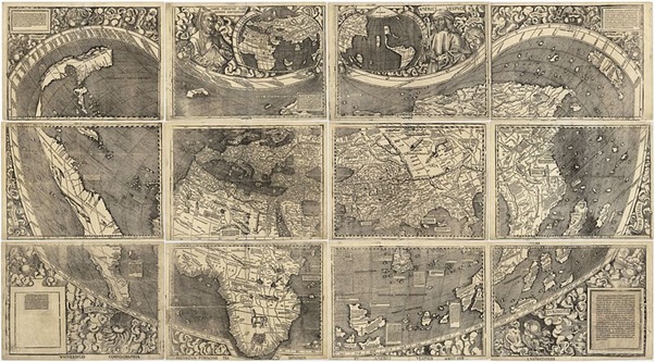
6. Waldseemuller’s Universalis Cosmographia (1507)
Martin Waldseemuller created one of the most ambitious maps of his time. Portugal, Spain, and the other colonial nations of the day jealously guarded their maps as state secrets because they didn’t want rivals in the “Have some beads for that shiny statue” trade. Waldseemuller managed to get his hands on a great deal of stolen information and used it to create the most comprehensive map he could.
But even then the map had a large number of inaccuracies, and would soon be replaced by more accurate maps with additional explored territories depicted. What really makes this map important is a little footnote. On the bottom left panel Waldseemuller inscribed a homage to one of the explorers that had discovered some of the locations on his map. Feminizing the name of Amerigo Vespucci, Waldseemuller gave us the name America.
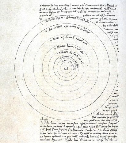
5. Copernicus’ De revolutionibus orbium coelestium (1543)
Today we take for granted that the Earth rotates around the Sun. But back in the day, this was a revolutionary and outright subversive idea. Suggesting such a thing could get you ridiculed, or worse. It was so bad that Prussian Renaissance man Nicolaus Copernicus didn’t even want to mention the thought.
However, he was eventually persuaded to release a book titled De revolutionibus orbium coelestium. Included amongst tons of mathematical proofs and astronomical observations was a map illustrating the idea by showing not just the Earth, but all seven then-known planets revolving around the Sun. Despite his own religious nature, this won him severe chastisement from the Church and led to him repudiating his own idea.
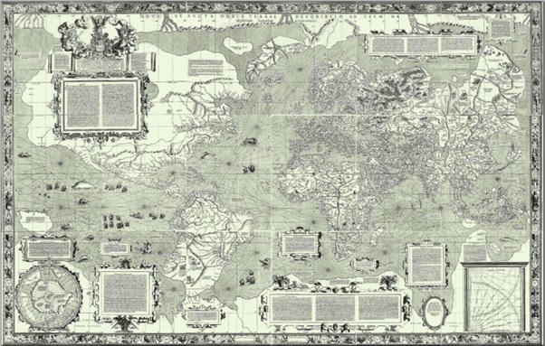
4. Mercator’s World Map (1569)
Like several other maps on this list, Nova et Aucta Orbis Terrae Descriptio ad Usum Navigantium Emendate Accommodata, better known as the Mercator Map, isn’t particularly accurate. It was designed specifically as an aid for navigators aboard ships, and as such it set aside accuracy in the name of practicality.
Before Mercator, navigational maps were best used as guidelines, not exacting tools. These maps were attempting to accurately portray a curved surface on one that was flat, so they couldn’t provide a true bearing for a navigator to steer by. The Mercator map changed this by deliberately distorting the land masses in order to allow true bearings to be reliably calculated. The upshot? Sailors could more easily sail from point A to point B. The downside? Africa and Europe look like the same size when Europe is actually 1/3rd as large as Africa.
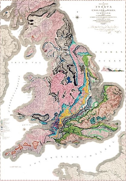
3. Smith’s Geological Map of England, Wales and Southern Scotland (1815)
Throughout much of history, theologians and religious scholars have posited that the world was created somewhere between 4,000 B.C.E and 8,000 B.C.E. As proof, they’ve used various genealogies or calculated the lengths of time between various historical(ish) events going back to (typically) the Garden of Eden. Referred to as the Young Earth theory, it’s generally a source of derision amongst anyone not running for political office these days.
Geologist William Smith created that change. Even before Darwin, his project to map the geology of Great Britain was showing some cracks in the Young Earth theory. His map revealed that the island’s underlying rock resembled a many-layered cake that would have taken millions or even billions of years to lay down and harden. Naturalists like Darwin would seize on this and use it as the launching ground for the theory of evolution.
2. Mackinder’s Geographical Pivot of History (1904)
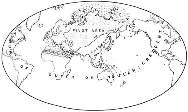
Halford Mackinder had a wacky idea. His thought was that certain key regions of the world had always, and would always, be the ones that influenced history. If you looked at the historical powers of the world, the largest and wealthiest populations, and the resources most important to them, you would be able to calculate the Geographical Pivot Point of History. The theory went that if you controlled this area, you could essentially control the world. Mapping this out, he came to the conclusion that this all powerful place was… Central Russia.
As crackpot ideas go, this was a doozy. Nevertheless, it was an idea that changed the world, albeit not for the better. During the first half of the 20th century, Germany would expend and take millions of lives repeating the mistake of Napoleon by invading Russia. Twice. The closest they came was Kursk, creating one of the largest battles in history but accomplishing nothing.
1. Cuban Missile Crisis Map (1962)
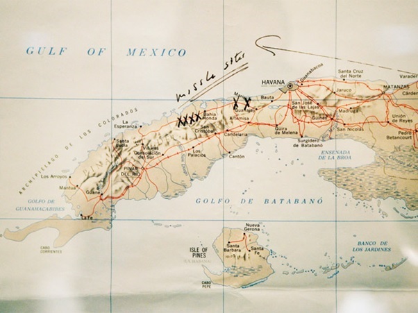
There are plenty of ways the world could end, but the biggest headline grabber since 1945 is nuclear war. Ever since the bomb was invented, people have been predicting that this was going to be how we as a species checked out. With an estimated 16,000+ bombs out there, it’s not a particularly farfetched idea.
At no time have we been closer than when the above map was sitting on the desk of President John F. Kennedy. On it he had marked out the position of Soviet nuclear missile sites in Cuba in October, 1961. Nuclear war could have started in no less than three different ways during the two week crisis. Soviet sub commanders had orders to protect Soviet ships by using torpedoes against the American blockade. The American Joint Chiefs of Staff unanimously believed invasion was the only solution, while Castro wanted to launch pre-emptive strikes. Fortunately Kennedy, with this map in hand, ordered the blockade and negotiations that successfully resolved the crisis.
